Sunday 11 April 2010

Hurshat Tal - A park for all seasons and tastes

There’s always a danger when speaking about Israel, of ‘overegging the pudding’ (a phrase which I have consistently used whilst not really understanding – much like my grandmother’s skills at egg sucking!). Having said that, however, I must really recommend Hurshat Tal National Park, right in the northern part of the Hula Valley, as it is the ideal place to spend either a few hours or, in the cabins or camping grounds, a day or more. The landscaped lawns of this delightful spot are well maintained and the well-appointed and kept campground occupy 100 of the approximately 190 acres of the national park. In addition to campsites, the campground has bungalows and rooms for rent, which is a worthwhile option for the canvas-phobic amongst us!

One reason for the lush lawns is a tributary stream of the Dan River, which cuts through the park and fills a large pond (really a small lake) which is open for swimming: best in summer, though. The, by now inevitable, waterslides here are among the highest in the country and the fishing area provides a relaxing diversion at surprisingly no additional charge. So, in theory, you can catch your lunch, cook it on the spot and them promptly recycle it again by using the water slides too soon after eating!!!!

About 25 acres of the national park were declared a nature reserve some time back, in recognition of the 240 rare Mount Tabor oaks growing there. Many centuries old, these trees are among the largest in Israel and should not be missed, as they will remind you of what the land used to look like before many settlers arrived. After the rainy season, in springtime, much of the park is ablaze with anemones and other wild flowers and the park becomes a tourist magnet, especially for Israelis.

Hurshat Tal really is an ideal informal base for exploring the Galilee, the northern Golan Heights, and the Mount Hermon area and, although seemingly remote, is but a few hours easy drive from central Israel.
You can find it on Roue 918 just south of Route 99 at Hurshat Tal junction, about 5 km east of Qiryat Shemona, just east of kibbutz Hagoshrim.

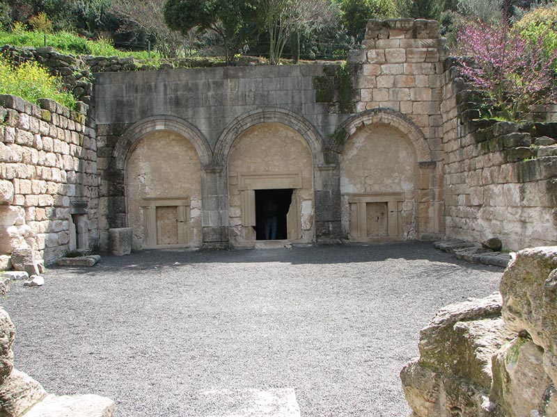
They all wanted to be buried at Bet She'arim

 Bet She'arim was a flourishing, wealthy Jewish town from the 2nd-4th centuries CE. At one point the town became the seat of the Sanhedrin (Jewish religious council), after Rabbi Yehudah HaNasi moved his study centre there. The Sanhedrin later moved, together with Rabbi Yehudah, to Tzippori – only some 15 km (10 miles) away and almost ‘up the road’, as it were. 

But the town's claim to fame was not, as you will readily see, who lived there, but who was buried there! Following Rabbi Yehudah's burial in Bet She'arim, it became at matter of honour for Jews from Israel and the diaspora to be buried close to him. You will find evidence that Rabbis Shimon, Gamliel and Hanina were all buried there in vaults and stone coffins decorated according to status - and pocket, no doubt.

File:Cave of coffins.jpg

Bet She'arim's former wealth is evident by the vast, ornately decorated necropolis discovered beneath the town. Numerous courtyards, corridors and stairways lead to the many underground burial chambers, all beautifully decorated in the artistic styles of the time, some from Greek mythology, such as the battle of the Amazons. What would we make of similar demands today? We can only speculate, but my guess is that it would be ‘lo with an alef!’

As usual, the inhabitants revolted against the yoke of Rome, this time in the year 351 CE, perhaps with the Jewish inhabitants getting a whiff of the impending fall of the Western Roman empire, just 60 years away. Unsurprisingly, however, it was brutally suppressed and the town, as well as surrounding towns, was burnt and destroyed. A climb to the top of the hill, where the remains of an ancient basilica still stand, will give you a beautiful panoramic view of the Jezreel Valley and Carmel Mountain Range. One of the vaults has been turned into a museum. Visit and marvel at the glory of the former town – and those who were buried there.

Bet She'arim can by found just off Route 722, the road linking Routes 70 and 75, south of Qiryat Tivon.
To view a Google map of this site, please click here 

Thursday 25 March 2010

When Nazis lived in Tel Aviv - the Sarona Templars Colony


In 1871, the first group of Templars, a radical German protestant group, who had been removed from mainstream Protestantism by the authorities, established the colony of Sarona, which they pronounced ‘Sharona’. Expanding and prospering under the Ottomans, the Templers remained committed German nationalists and when, in July 1918, Allied troops occupied the German settlements in Palestine, its inhabitants were interned in Egypt. In the 1920s Sarona was still a small settlement, but it prospered because of a ready market for its excellent produce. The first community, outside of Germany, to have a Nazi party chapter,  the German Counsels' office in Tel Aviv flew the Nazi flag at full staff!
The Templars sold their produce, especially Jaffa oranges (there’s an irony!) back to Germany, but their Reichsmarks were valueless as they were not recognised in Mandate Palestine. They opted, in many instances, to barter their produce for imported goods. In Tel Aviv, a Mercedes could be acquired in exchange for 50 cases of oranges - a snip!
After the War broke out, the Mandate government turned Sarona into a large internment camp. In July 1941, with Rommel appearing likely to overrun Palestine and join up with this ‘Fifth Column’, 198 people from Sarona, together with almost 400 from the other internment camps were transported to Australia where they remained until 1947. After the war, Sarona became a British military and police base and was the site of the first ever frontal Haganah attack on a British installation.

During the War of independence, the base was dubbed HaKirya because it contained the provisional capital of Israel until Jerusalem was secured and declared the capital. The Haganah and then Israel Defence Forces also used the Templar buildings as their first headquarters. Over the years, the military base's land area shrank, due to the high land value and sale to private companies, although the government retains many of its offices in the Kirya Tower in the southern Kirya.

                                                                                                                                                                              Thanks to my friend Sue Young for this photo.
The houses are currently being restored with a view to creating a village under the gaze of the three massive towers that make up the Azrieli Centre, which you can see in the above photo. Many of the houses are still dilapidated but even so it is easy to image what life was once like. At the time of writing (March 2010) there are gardens with picnic areas and on the tables are images of life in the original days of Sarona. Eventually all the houses will be restored, additional facilities will be provided and new people will start to live in this almost forgotten community.
The site is at the corner of Da Vinci and Kaplan and the area is called both HaKiyra and Machane Rabin, in memory of the assassinated prime minister.
Parking is not great but buses are plentiful.
To view a Google map of this site, please click here.


Wednesday 24 March 2010

The Haganah Museum, Tel Aviv. Not perhaps, Britain's finest hour.

If you are interested in how the early settlers formed defence groups and how they developed into the Haganah, this must be the museum for you. The museum is located on the site of the former home of Eliyahu Golomb, one of the founders of the Haganah and the ground floor rooms have been restored to recreate a sense of how the family once lived with biographical exhibits on Golomb's life – if that’s the sort of thing you like.

The upper floors lead you along a winding passage, with some thirty displays, many with multimedia narratives tracing Israel’s defence history from 1878, when the first "shomrim" or watchmen were organised to protect the early settlers, through the Haganah’s establishment in June 1920, the quelling of disturbances in the 1920’s and 30’s, and the struggle against the Mandate authorities up to the War of Independence.
Although most of the labels are in Ivrit, explanatory information is provided in English and it is possible to select an English voice-over for the video presentations.

On the third floor, you see the various ways the Jewish fighters hid arms inside farm machinery to escape British detection, and how they secretly made hand grenades and Sten guns in clandestine kibbutz workshops.
The museum is often full of visiting groups of soldiers and school visits, but they are - usually – well behaved. An English accent is probably not your best asset, as the designers make it quite clear whose side they are on!

The Haganah Museum is at 23 Rothschild Boulevard
Tel Aviv, opposite Independence Hall, right in the centre of the older part of town. Parking is a challenge but buses are plentiful.
To view a Google map of this site, please click here

Sunday 14 March 2010

This way to the Temple - The Ophel Gardens, Jerusalem


Two thousand years ago - during the period of the Herodian Second Temple the lower Jerusalem market was located at the southern end of what we now call the Western Wall in the Ophel, an area bypassed by many tourists today. We believe that shops were located on both sides of the lower market road. selling souvenirs, silver amulets, and animals for the sacrifices. Moneychangers converted the coins of foreign pilgrims into the local currency, much like they still do today (and you probably still got a terrible exchange rate!).
Discovered at the base of the wall, one extremely large rock has been partially reconstructed. It contains a replica of an ancient inscription, the original of which is on view at the Israel Museum, saying "To the house of the trumpeting to procl. . . " Biblical scholars are quite certain that the sentence ended with "to proclaim the Sabbath". Our very first direction sign! Imagine the trumpeter standing directly above the hawkers and market stall holders, warning them to conclude their business and go home to prepare for Shabbat.

Climb the steps that lead to the Hulda Gates and be amazed at their size and irregularity, cleverly designed to force pilgrims to walk slowly - an early form of crowd control. During the Second Temple period visitors entered through the triple gate on the right, and departed the Temple complex through the double gates on the left. All, that is, except mourners, who would make the journey in reverse. Why? So that people would automatically know their status and make the appropriate greeting of consolation.

The amazing Ophel Gardens are adjacent to the bus stop entrance to the Western Wall Plaza.

To view a Google map of this site, please click here

Monday 8 March 2010

The Supreme Court, Jerusalem. Proving that no-one is above the law.

For many years after the founding of the State, the Supreme Court was housed in unsuitable premises, but in 1984, the Rothschild Foundation (called Yad Hanadiv in Hebrew) made a formal offer to the Government to donate a permanent building for the Supreme Court. As you can imagine, the offer was gratefully accepted and there was an architectural competition in 1986, attracting entrants from all over the world. The winners, from Israel, were the brother-and-sister team of Ram Karmi and Ada Karmi Melamede from Tel Aviv. Being built surprisingly quickly, the new Supreme Court building was dedicated on November 10, 1992. 


When you walk around the magnificent site today, you can only marvel at the ingenuity of the architects, who combined biblical and Talmudic legal references into the design. For example, The site of the building would be in Kiryat David Ben Gurion, adjacent to both the Knesset, the legislative branch of government and the executive branch of government but, because the law should always be above the government, the building was put on a site physically above the Knesset, so that the MKs should always be aware of their position (well the idea was good, ast least!) The building integrates post-modern architectural elements, too, reflecting Jerusalem’s rich architectural history and is truly an exciting element of anyone’s stay in Jerusalem.

Tours are held daily and English tours are usually at 1200, but check the details for the day you plan to visit, in case of unscheduled changes.

You can access the building from various directions, but I think it's easiest from Sderot Rothschild or Sderot Yitzchak Rabin.

To view a google map of this site, please click here.

A walk on the wet side - Hezekiah's Tunnel in Jerusalem

Hezekiah's Tunnel or, as some people call it, the Siloam Tunnel, was dug just before 701 BCE during the reign of King Hezekiah, underneath the Ophel area in Jerusalem and features in the story you can read in Tanach, in 2 Kings 20 and 2 Chronicles 32. When you walk through it – and I really hope you do – you have to keep reminding yourself that this is one of the few intact, 8th century BCE structures in the world that the authorities (whoever they are) will allow you to!
The tunnel, leading from the Gihon Spring to the Pool of Siloam, was designed to act as an aqueduct to provide Jerusalem with water during an impending siege by the Assyrians, led by Sennacherib. The curving tunnel is 533 m long (just under 1750 ft), and conveyed water along its length from the spring to the pool on a 0.6% gradient.
An inscription found in the tunnel says that it was excavated by two teams, one starting at each end of the tunnel and then meeting in the middle. I know this sounds like the joke about the navvy who bid to dig the Channel Tunnel with a mate for £100 each by starting at each end and digging towards each other, but it this case, it really happened! It is clear that several directional errors were made during its construction as the tunnel isn’t in the straight line it probably should have been. Once upon a time we were told that the tunnel may have been formed by widening a pre-existing natural cleft in the limestone, called a karst, but it seems that this idea has been rejected by scholars now.

The water reaches up to about 0.75 m (2.5 feet) even in the summer and the hike through the tunnel takes about 45 minutes, The tunnel gets very low (about 1.2 m, 4ft or so) and can be very narrow, so there is a health / width warning here.. The floor is fairly smooth, as are the walls, but there are a few rough rocks, so take care.
If you do decide to go, you should bring a torch, with spare batteries. You should also dress appropriately, with shorts and sandals, or shoes that you do not mind getting wet. Watch out for that low roof and it’s my advice that it’s probably best to go with a tour group.
You can get to the tunnel ends via Ma'alot Ir David or Derech HaShiloach, just south of the Old City.

Sunday 7 March 2010

Step back into Mishnaic times in Qatzrin (or Katzrin)

 After the 2nd century Bar Kochba rebellion against the Romans, Jews were banned from Jerusalem, the city was ploughed up and renamed and another great Jewish Dispersion began. Many of the exiled Jerusalemites headed north to the Galilee and settled in the Golan. Over the next two hundred years, they built nearly three dozen thriving, prosperous settlements in the region. One of them was Qatzrin (sometimes spelled Katzrin), now the capital and main administrative centre of the region. The area was first surveyed well over 100 years ago, initially by Sir Lawrence Oliphant (who I've written about in the section on the names behind the streets), who was trying to encourage Jewish emigration from Eastern Europe and then by the German engineer Gustave Schumacher, looking for the best route for a railway from Damascus to the Mediterranean Sea. 

Several buildings at Qatzrin have been restored, allowing visitors to step back to mishnaic times and actually experience village life from over 1500 years ago. 

Image courtesy of www.HolyLandPhotos.org.
 Ruins on view in the ancient city include typical 'three roomed houses', remains from the town's main synagogue and its impressive arched entrance, only rediscovered in 1968, engraved symbols of the Jewish inhabitants and inscriptions dedicated to well-known figures of the period. Rabbi Eliezer HaKappav established the synagogues of this region after the exile, and Qatzrin best exemplifies the workmanship of these houses of learning from around the period of the Talmud's completion. It appears that, at one time, the synagogue underwent expansion and a second storey was added, possibly to accommodate women. It seems that the Synagogue Building Committees may have an ancient and honourable lineage! The site is a fascinating one for all the family and being close to the famous Golan wineries doesn't hurt, either!

Access to the ancient site could not be easier. The carpark is directly off Route 9088 which runs between Routes 87 and 91, near the industrial area. 

Thursday 4 March 2010

Ein Gedi. It's worth the trek to the waterfall

It is difficult nowadays to imagine what it must have been like for the early tourists to Ein Gedi, before the easy road to the site was built. Trekking through the inhospitable Judean Desert for days must have been tough for even the hardiest traveller, but the journey was worth it, if only to experience the greenery, flowing waterfall, cool shade and magical ambience of Ein Gedi. Even the United Nations, not noted for hyperbolae, has singled this unique site out for special mention. The Nature Reserve is large and you would only really be sensible to take the extended tours with an experienced guide (and lots of water!) but almost everyone can take the two hour trip up Nahal David. Because of its unique microclimate, the reserve is the home to a very special blend of flora and fauna, including the tropical moringa tree, which reaches no further north than this anywhere in the world. You will almost certainly see ibex, hyrax (although they are VERY shy) and wild goats, now not so wild at all. The question is often asked about where the water comes from in such abundance, here in the middle of the desert.

We all seem to forget that the desert can experience rain - and even floods - in winter and the water permeates through the top surface, percolating down until it reaches a stratum of hard rock and finds a way out. (well, there's the geological bit out of the way). Happily for us this happens right here! There is such a lot of history here, from Stone Age settlers from well over 5000 years ago, via David pursued by Saul and the Essenes ( better know for their settlement at Qumran) to a site occupied by supporters of Bar Kochba. These days the reserve can be easily reached from Route 90, the Dead Sea road, between km 244 and 245. 

To view a Google map of this site, please click here. 

Tuesday 2 March 2010

The Hecht Museum, Haifa. A hidden gem in the North


Dr Reuben Hecht was one of the most influential people in the pre State and early years of Israel. Scholar, businessman, diplomat, academic, advisor to Prime ministers: he was surely one of the most modest and yet most powerful people in Israel.
Over sixty years he also amassed one of the most exceptional private collections of ancient archaeological artifacts and modern art. But far more than that, he bequeathed it all to the university he helped to found in Haifa.
The Reuben and Edith Hecht Museum, to give it its full name, is housed within the main university complex and has two distinct sections, those of the ancient archaeology of the region and of art, mainly of the Impressionist period and of Jewish artists who died in the Holocaust. The former demonstrates the connection between the Land and the People of Israel over thousands of years, with special reference to the fine artistic work of its inhabitants and the lives and times of the Phoenicians. 

The ability to walk amongst the reconstructed ruins of a Phoenician settlement, recreated in the museum, to see the remains of a ship nearly two and a half millennia old or to examine a wonderful ancient synagogue mosaic, should not be missed. But nor should the chance to see works by Monet, Manet, Pissaro, Van Gogh and Modigliani and a host of other Impressionist ‘greats’ - all tucked away in Haifa.

There is free admission and there are guides available in English. If ever a museum deserved the accolade 'hidden gem', this is surely it!

You can access the university main building on Route 672 on Sderot Abba Hushi, close to its junction with Route 705.  You can't miss the tower: it's visible from miles around.  It is also easily accessible by bus from the centre of Haifa and the railway station.

To view a Google map of this site, please click here 

A hearty walk in old Jerusalem – The Cardo

Every Roman city was laid out to the same design and Jerusalem was no different. The 6th century church floor in Medeba, Jordan has a mosaic map of Israel with many place names in Greek. At its centre is a depiction of Jerusalem with walls, gates, churches (with red roofs – very mediterranean) - and the Cardo. It is depicted with two rows of colonnades running the length of the city from north to south.
Following the unification of Jerusalem in 1967, teams of Israeli archaeologists spent many years excavating the city. In the 1970’s, Nahman Avigad's team excavated the Cardo area for about 200 metres (220 yards), from the time of Emperor Justinian in the first half of the 6th century CE. An earlier section of the Cardo was constructed in the Roman period beginning at the modern Damascus Gate in the north, but it was not extended this far south until some centuries later.

The central street of the Cardo is 12 metres (39.5 feet) wide and was lined on both sides with columns. The total width of the street and shopping areas on either side was a staggering 22 metres, easily the equivalent of a 4-lane dual carriageway today. This street was the main thoroughfare of Byzantine Jerusalem and served both residents and the many pilgrims. Large churches flanked the Cardo in several places.

As can still be seen in modern Italy today, the columns supported a roof that covered the shopping area and protected the patrons from the sun and rain. Then, it was built of wood –today we just have to imagine it. Currently the Byzantine street is about 6 metres (18ft) below the present street level. The steps down are steep but quite safe.

http://static.panoramio.com/photos/original/5830908.jpg
I acknowledge the copyright of the owner of this photo

Today, the Cardo is home to souvenir shops, but it is well worth the short walk to transport yourself back to Roman times – and under cover too! It is in the heart of the old City of Jerusalem and is well signposted, just a brief walk from the main car park or you can access it from Rehov Chabad or Hayehudim.


The Jerusalem Biblical Zoo. You may enter two by two, or even seven by seven!


The very first public zoo in Jerusalem was opened as a petting zoo for children in 1928 and was, to put not too fine a point on it, pretty grim. As the city grew and ideas about zoo management, developed, the Jerusalem Biblical Zoo, as it is still unofficially known, moved and expanded. It now stretches across an area of 25 hectares (62 acres) in a delightful valley on the southern outskirts of Jerusalem, surrounded by green hills and new neighbourhoods. The zoo, now named for its munificent sponsors, the Tisch family of New York, is built around a small lake which is located near the entrance. The artificial lake relies on recycled water and is fed by several linked pools and waterfalls. It is artfully surrounded by spacious lawns and shady beauty spots, often the home to the zoos feathered inmates. 

The zoo is built on two main levels which house most of the animal exhibits. The main, circular route extends the length of both levels, connecting most of the sites on the zoo grounds. Several side paths connect the two levels, allowing you to decide on your own route and exhibits are cleverly situated along these paths as well.

Inevitably, the zoo’s main emphasis is placed on animals mentioned in the Bible. Sadly, the majority of these animals became extinct in Israel, mostly in the twentieth century and some within living memory, due to indiscriminate hunting, habitat destruction, and the feverish – and often uncontrolled, pace of construction and development. These animals include creatures like bears and lions, the Persian fallow deer and Arabian oryx, the cheetah and the Nile crocodile.

An additional emphasis in the zoological collection involves the preservation of endangered species from around the world. In this group the zoo is home to the Golden lion tamarin, the rarer of the macaws and cockatoos, the ibises, and the Asian elephant and there was great excitement in Israel when a baby elephant was born in December 2005. Of course, it's grown a bit since then, k'nein a horah!

Most of the animals in the zoo live in large enclosures, designed to resemble – as close as possible - their natural habitats..

A few of the animals were confiscated from smugglers, but the vast majority were born in captivity. The zoo management make it a matter of policy that none of the animals in the Jerusalem Biblical Zoo were collected directly from the wild. They firmly believe that the capture and removal of animals from the wild for the purpose of displaying them in captivity is unusually cruel, as well as illegal. Good for them!
Drive to the zoo from the Begin Route, past the Malcha Shopping Mall and the Jerusalem Technology Park to Derech Gan Hachayot, at the junction of Sholov and Moda'i. There are good bus links and, when it runs,  the Tel Aviv Jerusalem railway stops at the new Zoo station


Bon Giorno Jerusalem - the U. Nahon Museum of Italian Jewish Art.

It's hard to believe, but just a few steps from the bustle of Jerusalem's Ben Yehudah Street is a step back into the world of Italian Jewry in the U. Nahon Museum of Italian Jewish Art.

Founded in 1981, and housed in a former German Catholic Institution ( the architecture gives the game away!) it collects, preserves and displays objects from Jewish life in Italy over the last six hundred years..
The collection of Arks and religious objects from the Renaissance and Baroque period was dismantled and carefully brought from Italy to Israel in the 1960s by Dr. Umberto Nahon, in collaboration with the Jewish communities of Italy and Israel.

Many of these rare items were found in sadly deserted synagogues that belonged to defunct communities. Once in Israel they were stored close to the synagogue until 1982, when the Museum was officially opened to the public.
The museum also houses a functioning synagogue, transported in sections from Conegliano in northern Italy in the 1950s, but only after the authorities there were sure that there were no Jews left in the town.


Other gems include the oldest parochet ( Ark curtain) in the world, dated 1572, from Ferrara and a host of other beautifully made items, each one a work of art in itself. A sukkah from 18th century Venice, a fascinating parochet from Pesaro, celebrating the marriage in 1620 of Rachel Olliveti to Judah Montefiore, one of Sir Moses' ancestors and a Torah keter (crown) from Alessandria in 1849, decorated with cannons all have their stories to tell.

Your trip to Hillel Street, just up from its junction at the bottom of Joel Solomon St, will certainly be worth it.
I couldn't get a photo of the exhibits: they are very strict about it :-(

To view a Google map of this site, pleae click here 


Wednesday 24 February 2010

Miqveh Yisrael. Old but still attractive

As you race along the Ayalon Highway, Route 1, between Ganot and Kibbutz Galuyot interchanges, try to cast your eyes (safely, of course) south towards Holon. Here you will find one of Israel's hidden gems, now the Mikveh Yisrael - Vinik College of Agricultural Technology, but originally just Mikveh Yisrael. This was the very first modern Jewish agricultural settlement in the country, set up in 1870 by Karl Netter, an Alsatian Jew, on behalf of the Alliance Israelite Universelle, broadly the French equivalent of the Board of Deputies. Not surprisingly there was early friction between Netter and the Zionist leadership as the school insisted on French as the language of instruction, but these little local difficulties were overcome in time and it is sobering to think that on this spot in 1898, Theodore Herzl met Kaiser Wilhelm II! Much later on, during the War of Independence, the 'Davidka' mortar was manufactured here in great secrecy. In reality it was just a large pipe and made more noise than the size of shell it fired deserved, but it seemed to have the required effect nonetheless. 

Some of the specimen trees are as old as the settlement itself, especially the Bengali Sycamore, with its hanging roots and multiple trunks, all actually one single tree. The highlight of any visit will be the botanical garden to the east of the site, originally planted in 1930. Now, with nearly fifteen hundred species and genera of foliage, medicinal, climbing and hedging trees and plants, this backwater in the heart of bustling Holon is just amazing. You reach Mikveh Yisrael by turning south at Tzomet Holon on Route 44, onto Levi Eshkol Avenue. Turn left at Kikar HaLochamim and follow Qugel Avenue to the traffic lights at the southern entrance to the site. The museum, like a few others in Israel, is only open by request (weird, but true). I suggest you call 00972-3-5030489 first, but from Israel just dial 03-5030489.


To view a Google map of this site, please click here

Sunday 21 February 2010

The Valley of Elah. Who's Looking for a fight?


The Valley of Elah is best known as the scene of the Biblical battle between David and Goliath (Elah means terebinth, the turpentine tree, commonly found in this area). The Brook of Elah, which lies in the heart of the valley, is a seasonal creek, more of a wadi really, which runs dry in the summer months. Most probably the brook from which David chose five smooth stones in preparation for battle, it is the ideal place to recreate in your mind's eye what is arguably perhaps the most famous story from the Tanach. Budding amateur archaeologists should not to get their hopes up over the possibility of discovering a stray piece of Goliaths armour, as the only thing remaining from this three-thousand year battle is the beautiful scenery. Nonetheless, the story takes on a whole new dimension when you read it whilst standing at the site of the action. So take a Tanach , bookmark 1 Samuel 17, make sure that you have adequate water and sun protection and set off on an easy drive from both Jerusalem and Tel Aviv. 


Turn off Route 1 on to Route 38 in the direction of Bet Shemesh and you find yourself passing through the geographic transition area between the coastal plain and the Judean hills. Just before reaching the petrol station at the junction of Routes 38 and 375, at Elah Junction, you will pass over a concrete bridge - beneath it is the Brook of Elah. Stop, park safely, walk back to the brook side and start reading. You will not be disappointed that you made the journey.

To view a Google map of this site, please click here

Thursday 4 February 2010

Avraham woz ere - Tel Beer Sheva

There are many archaeological sites in Israel and many with links to the Patriarchs, but the unique feature of Tel Be'er Sheva, which is located to the east of the present city, is that it has been virtually completely restored, with the archaeological ruins represented by everything below a white line. OK, so most of the remains are from the 8th century BCE, from the rule of king Hezekiah, far too late for a sign to be found saying 'Avraham woz ere’, but there are some carved rock dwellings which seem to have belonged to the earliest Israelite period (12th century). It appears that the town was home to some 400 people mainly military troops and proto civil servants who administered the kingdom. The peasantry would have lived in villages and farms outside the town.

Next to the main gate is the well, some 80 meters deep, dug in about the 10th century BCE, but there is a tamarisk tree planted next to it and it isn’t hard to imagine it (or its ancestor) being there in the days of Avraham. Just like at Hazor,,the water was brought up from a very efficient water system, with steps leading down to the water level and a separate flight coming up. Shades of Tevye!
The large (ish) governor's palace, has three main reception rooms, but smaller four-room houses, typical Israelite dwellings of that period, are found in other places, built against the wall - well it seemed such a waste of effort to build another one, I suppose. Opposite the four-room houses is a cellar building, which goes down to the bedrock, probably explained by the destruction by king Hezekiah when he broke down the heathen temple. You can read the whole story in II Kings 18. 

However, to me, the most amazing site is that of standing at the tel and seeing the train to Dimona wend its way slowly past the foot of the mound, with the city's sewage works close at hand, as is the modern Arab town of Tel Sheva. What would Avraham have said?
Tel Beer Sheva is just off Route 60, about 5km east of the new city. If you take the eastern bypass road - and you should – it is less than 1km from the junction with route 60.
To view a Google map of this location, please click here. 

Wednesday 3 February 2010

The amazing Art of Glass Exhibition, Arad.Not just for looking at


If you think that you have seen all the craft glass works you can take, then this amazing exhibition / museum will have you thinking again. After watching a fascinating video about the artist, his philosophy and his technique, Gidon Fridman, the artist, guides you personally through his life’s work, as he explains with passion and excitement how he has developed a completely original way of working in glass. Not for him the cute mezuzah covers or challah plates. His installations appear, for example, as holograms, with faces of girls which seem to move as you walk around them. The chess pieces (like the king and queen below) are delightful, but his coloured glass ‘bodies’ are both artistically and technically superb – and it’s good to see that the male models for them appear to be Jewish!

His method of producing the works (I can’t think of another word to describe them) is unique as, unlike other glass artists, he uses window glass, which he colours in vibrant hues and drapes it, at very high temperatures, over mould ‘negatives’ he designs himself. Each piece tells a story and is a treat for the eyes and ‘neshama’ (as he says) but nothing prepares you for the final piece, his Holocaust memorial, which took over three months of concentrated work to produce. You will leave the museum stunned by the technical wizardry, artistic feeling and sheer passion of the artist.

The Art of Glass Museum is at the end of Sadan Street street in Arad, in the ‘Artists Quarter’. You access it directly from Route 31 (east of Be'er Sheva), turning right at the first roundabout and following the signs. There are other artists at work in the area, too and you should make time to see them all.

Tuesday 2 February 2010

Independence Hall, Tel Aviv. Go where Israel was born

On April 11th,1909, sixty six families gathered on the sand dunes by the sea just north of Jaffa, to take part in a lottery for plots of land for Ahuzat Bayit, a new Jewish neighbourhood. Meir Dizengoff and his wife Zina won lot 43 and built their home on it. He served as head of the new neighbourhood committee, eventually becoming the first mayor of Tel Aviv.
In 1910, at a general meeting of the Ahuzat Bayit residents, the name of the neighbourhood was changed by majority vote to Tel Aviv, inspired by Herzl’s book “Altneuland,” .The title given by Nahum Sokolow to his Hebrew translation was Tel Aviv, which means “Hill of Spring.” Following the death of his wife in 1930, Meir Dizengoff donated his house to the city and asked that it be turned into a museum. Expanded and renovated, in 1936 it became the Tel Aviv Museum of Art.


On 
Friday, May 14th, 1948, at 4 p.m. – eight hours before the end of the British Mandate in Palestine and shortly before shabbat – the members of the People’s Council and Executive together with invited leaders gathered there and listened as David Ben-Gurion, head of the People’s Council, the Zionist Executive and the Jewish Agency, declared the creation of the State of Israel.
After the reading of the declaration of independence, Rabbi Fishman-Maimon recited a Sheheheyanu and members of the People’s Council and Executive signed the scroll. The ceremony concluded with the singing of “Hatikva”.
Today you can visit the historic hall where most of the exhibits are original, while others have been reconstructed in precise detail. transporting the visitor back to that incredible event. Most of the pictures displayed at the time, part of the Tel Aviv Museum’s collection from the day the state was declared, remain on the walls. You can listen to the original recording of the ceremony and view a 16-minute film describing the events of the period and the history of the building.
Check out the different chairs and find out why they didn’t match.

Independence Hall is at 16 Rothschild Boulevard, in the heart of the city.

To view a Google map of this site, please click here.

Sunday 31 January 2010

Hazor - from Yavin to Yadin


Hazor, one of the most important sites in our early history was one which also helped to make the reputation of Yigal Yadin, soldier, scholar, archaeologist and politician. Tel Hazor can be split into two parts: the 30-acre (11 ha) acropolis and the 175-acre (70ha) lower city. It seems that Hazor was already important in Abraham's time and was the largest fortified area in the land during the Israelite period (ninth century B.C.E.).

Ideally located on the Fertile Crescent, Hazor traded with cities in Babylon and Syria and its bronze industry used tin brought from abroad. The king of Hazor, who held the title of ‘Yavin’, was considered an equal with the kings of other important centres, such as Carchemish, Aleppo, and Qatana. The Tanach refers to Hazor as "the head of all those kingdoms" (Joshua 11:10).

Your visit to Hazor is a trip back through time, as you encounter buildings from different periods: fortifications from the middle Canaanite period; a large building (called the "castle") from the late Bronze Age; a casement wall and gate which some think was built during King Solomon's reign (even naming this type of gate a ’Solomonic Gate’); a late-Canaanite altar; and storehouses possibly constructed at the time of King Ahab.

The waterworks, presumably built during Ahab's reign were designed to provide the residents of Hazor with a steady supply of water even when under siege. When completed, they no longer had to carry water from springs outside the city, but drew ground water from a 45-metre-deep shaft and well, reached by steps without handrails. You decide which was easier!

Finds from Tel Hazor are displayed at a museum at the entrance to Kibbutz Ayelet Hashahar, just opposite the site, which you should visit before going up to the site. The view from the top of the mound is breathtaking and shows just why it was so important.

Hazor can be found on Route 90, 7 km north of Rosh Pinah.

At Tel Arad you can just never tel!

If you are looking for a Cannanite city, a Solomonic outpost, a site where Hashem and an Asherah were worshipped at the same time and a link to our earliest history, then Tel Arad is for you. On a site occupied for over 5,000 years, a large Canaanite town was built. We are told in Bamidbar 21 that its king drove the Israelites back when they tried to advance into the Promised Land from the south. After its capture by Joshua, it was part of the tribe of Judah, and, apparently the "children of the Kenite" (Moses' father-in-law, perhaps) lived in the town. The town was developed and fortified probably by Solomon who, strangely, built a temple to Hashem on the site of a hilltop sanctuary of the Kenites - not quite the story we have all been brought up with, but perhaps he was just keeping the non Jewish residents happy: a sort of biblical Community Cohesion, perhaps?  Shortly afterwards, in 920 B.C E., it was captured by Pharaoh Seshonq, the Shishak of the Tanach, but was soon recovered by the kingdom of Judah, to which it belonged until its fall in 586 B.C.E. Its location on important trade routes meant that Arad retained its importance into the Roman period, with King Herod even building a bakery there. Arad was finally abandoned only after the Islamic conquest in the seventh century C.E.

When you visit the site, you will see excavations of the ‘Arad House’, a type not unique to here, but best preserved here. It looks like the Caananites bought ‘off plan’, even in those days. Archaeologists have found piles of broken pots (called ostraca) with writing on them stating that they were ‘for the House of Hashem’ and I leave it to you to decide whether they were used ‘on site’ or just as a label for a sacrifice being sent to the temple in Jerusalem?

Tel Arad, now a National Park, is a fascinating glimpse into a part of our ancient history too often glossed over. Your trip will certainly be worth it.
It can be found on Route 80. Turn north on Route 31, east of Beer Sheva at Tel Arad Junction. It can easily be combined with other trips in the area.

To view a Google map of this site, please click here. 

Friday 29 January 2010

A Jerusalem house with a history - Bet Ticho


Go for a coffee and cake ( or a yummy salad) at the delightful Bet Ticho in Jerusalem and you might just wonder about the attractive surroundings, as you sit in the shade of the mature trees. The history of the house is certainly worth retelling. 


It was built in the late 19th century by Hajj Rashid, a prominent Arab, who sold it to Wilhelm Moses Shapira, a Jewish convert to Christianity. He dealt in ancient Judaica, much of which he manufactured in his own workshops. One of these was a set of narrow strips of parchment which he claimed had been given to him by Judaean Desert bedouin and contained the oldest known version of Sefer Devarim. The British Museum was about to pay £1 million for the texts ( no small figure in those days) when they were denounced as forgeries by a French expert. This saved the museum enormous embarrassment, but Shapira could not take the shame and committed suicide, still protesting his innocence. Some scholars now believe that they were actually genuine.

Dr Avraham Ticho was the most eminent eye doctor in Jerusalem, having studied in Vienna before arriving in 1912. He married his much younger cousin Anna, a skilled artist when not helping her husband run his clinic. He treated Emirs and paupers alike and was much loved. When he was stabbed in the anti Jewish riots in 1929, the Chief Rabbinate even issued a notice asking everyone to pray for his recovery! After his death in 1960, Anna decided that, on her demise, she would bequeath the house to the people of Jerusalem.

Bet Ticho can be found at 7-9 Rechov Harav Kook, off Derech Yafo, near Zion Square.

To view a Google map of this location, please click here

Korazim -The Cathederal of Moses


The ancient Galilean city of Korazim (or Chorazim, depending on your transliteration) was first mentioned in the Second Temple period, when it was famous for the high quality of its wheat crops. We know it grew in prominence in the Mishnaic and Talmudic periods and features in christian writings as it, along with the local cities of Bet Zaida and Kfar Nahum were cursed for not accepting the teachings of a notable local rabbi. It would seem that his teachings continued to be discounted by the locals, as today, the most fascinating part of your visit to the site will be to the Byzantine synagogue, built around 1600 years ago, some 300+ years after his life. It was constructed of basalt, the volcanic rock so evident in the area and on it you can see very ornate carvings of plants, people crushing grapes underfoot and animals. Easily visible too are lions and an eagle as well as a bird pecking at a bunch of grapes.


The so-called 'cathedral of Moses' is actually an armchair carved out of the rock and most likely the seat for a very important community member. An Aramaic inscription has survived, but the cushions which would have made the seat somewhat more comfortable have, sadly, not!

The Israel Parks Authority have reconstructed a mikvah, two ancient homes and an olive press, showing the life and times of the early inhabitants. We were told that the shy Syrian hyrax can sometimes be seen sunbathing on the rocks or hiding beneath the jujube trees which grow in the vicinity, but it must have been one of its ‘shy days’ when we visited!

Korazim National Park is on Route 8277, just 10 minutes drive from Amiad junction on Route 90, north of Tiberias.

Sunday 24 January 2010

Park Jabotinsky -From Manashe to Ze’ev

Located on the furthest south spur of the Carmel mountains, the Jabotinsky Park site features forest walks, a children’s playground, the Achaim Sculpture Garden, the Shuni Archaeological Museum Fortress, as well as a camp and educational center. The park was named for Ze'ev Jabotinsky, a prominent Zionist militia leader, whose followers broke from the Haganah to form the more right wing Irgun during the British Mandate. The Irgun used Shuni as their militia headquarters and training ground and launched many operations from the site.
Shuni is situated on lands belonging to the biblical tribe of Menashe and is mentioned in the Talmud as the village of Shumi. At the end of the nineteenth century, Effendi Salim Houri, a wealthy Haifa land owner, bought the area, extending his personal property from here to Zichron Yaakov. He added buildings onto the earlier site, one of which was a granary – ‘Shuni’ means granary in Arabic. In 1914 Baron Edward de Rothschild bought it for an agriculture school for new Jewish farmers.
JNF archaeologists have uncovered early Roman baths along with a large amphitheatre, probably used by wealthy pagan Romans who lived in nearby Caesarea. The Christian Byzantines tore down the sacrificial platform, destroyed the stone columns that led to the pool area and instead built an olive press. The theatre is now restored and is used today as an entertainment area for concerts and other activities.
The Romans also built high-level aqueduct to bring fresh water from Shuni Spring, 7 km (4.5 miles) to Caesarea during Herod's rule. The aqueduct delivered water at a gradient of 1:5000, which their engineers had discovered was enough to allow the water to flow without scouring out the channel.

The Park also features the Achiam sculpture museum,with about 90 sculptures in stone, basalt, wood and bronze. His works range over diverse subjects including biblical personalities, women, musicians as well as universal pain and suffering ("Hiroshima," "Auschwitz," "Kaddish"). The sculptures stand on the original Roman mosaic floors, an interesting mix of the ancient and modern.

The museum houses Roman findings as well as relics from the Irgun training camp. Sometimes, former Irgun members are on hand to tell of their exploits.
The Jabotinsky Park, just five minutes drive north of Binyamina on Route 652, is a fascinating blend of ancient and modern history, as well as having lots for families to do and see.

Meet the Freedom Fighting Farmers - The Palmach Museum, Tel Aviv

When the British Mandate Authorities called on the Jewish community to form a militia in 1941 to prepare for a predicted invasion by Rommel, little could they have imagined what this ‘Striking Force’ – its Hebrew acronym was ‘Palmach’ – would become.

When the danger receded, the British formally disbanded the Palmach, but it went underground, based on kibbutzim and trained hard for the inevitable conflict to come.

The Palmach Museum is really an innovative audio visual experience, where for 90 minutes you can get a small idea of what life was like for the thousands of their volunteers.


You can also get a potted history of the War of Independence, in which the Palmach provided 25% of the military strength. This development is told through the personal stories of a fictional composite group: sabras, new arrivals and Holocaust escapees, Ashkenazim and Sefardim and you live with them, sharing their good times and bad.

The visit, where you walk through a number of high-tech ‘stage sets’, is conducted in timed groups (remember, this is a ‘museum’ without exhibits) and begins and ends in a commemorative hall for the over 1100 Palmach troops who fell fighting for the establishment of the State of Israel.

Whilst the tour is in Hebrew, you can ask for English language headsets, so you won’t miss a thing. Pre-booking is essential on 03-6436393 or fax 03-6436964.

The fascinating Palmach Museum can be found on 10 Rechov Haim Levanon on the campus of Tel-Aviv University, next to the Eretz Yisrael Museum.


The Eretz Israel Museum, Tel Aviv. The whole land at one view ..........


There are many museums in Israel dedicated to specific themes: art, cities, archaeology etc, but there can be few museums with such a wide variety of exhibits as the Eretz Israel Museum in northern Tel Aviv. Archaeology, Judaica, Ethnography, History, Culture, Arts and Crafts; each is shown in pavilions and outdoor settings to its best advantage.

The centre of the museum ‘park’ is Tel Qasile, an ancient Philistine site which has been extensively excavated, but you can also see the ‘Man and His Work’ Centre, with the tools and implements used in ancient times, usually accompanied by a reference from Jewish sacred texts (Tanach, Talmud, Midrash), right up to more modern times. One of the most amazing sights is to stand facing south at the ‘dig’ site with the Philistine settlement in front of you and the skyscrapers of Tel Aviv in the background. Three thousand years of occupation in one view!

The Craftsmen’s Arcade, a reconstruction of an oriental bazaar, might give you the chance to watch traditional workmen and women weaving, glass blowing and sitting at the potter’s wheel whilst in the Nechushtan Pavilion you can see how copper was mined and smelted in the Timna area from earliest times. Reconstructed diggings show how Egyptians and others toiled in unbelievable conditions to win the precious metal ore.

With a landscape garden featuring a wine press, an olive oil press and water powered flour mill, examples of almost every ancient native plant and tree in the Land of Israel, fountains, ancient mosaics and other fascinating items, the Eretz Israel Museum is undoubtedly a very special location and well worth your visit.

Located at 2 Rechov Chaim Levanon on the campus of Tel Aviv University, the museum is in the northern suburbs of Tel Aviv.


Thursday 14 January 2010

Popeye the Philistine?- Ekron


Ekron was one of Philstia's five cities (the others were Gaza, Ashkelon Ashdod and Gath) and is one of the largest Iron Age sites in Israel. More than 100 oil presses were found here, as well as the Ekron Inscription (confirming the site as Philistine Ekron). To the tourist, the highlights of a visit are the reconstructed Philistine street, featuring an oil press, a potter's wheel, (since many jugs were produced on site to transport the olive oil) and a loom, as apparently there was quite an active textile industry, as well as the Museum of Philistine Culture (yes, they really had some!)


Ekron was first mentioned in Tenach in Joshua 13:2-3 and, in relation to the Ark of the Covenant, in I Samuel 5;10. With the arrival of the Philistines (apparently one of the Sea Peoples who may have arrived from Greece or Cyprus) in the twelfth century BCE, Ekron became a large fortified, urban centre, supplying Egypt and Assyria with huge quantities of olive oil, as much as 700 tons a year - the largest olive oil industrial centre in the ancient Middle East. Liquid was extracted from the crushed olives with the help of weights and log (an example of such an installation can be seen at the reconstructed street). The liquid was then transferred to huge jugs where the oil rose to the top and the water was drained. Tenach tells us the Philistines also had the monopoly on iron working in the Land of Israel during the period of the Judges, preventing the Israelites from metal smithing aad producing better agricultural tools..... and weapons.

Ekron, a fascinating site which proves that the Philistines get a 'bad press', is located on Kibbutz Revadim, off Route 3 , just north of its junction with Route 40, west of Bet Shemesh. route 6 is close, but access is limited.

To view a Google map of this location, please click here.

Wednesday 13 January 2010

Bat Shlomo - The village that time forgot.

You will often hear people claiming that they have found a village in Israel ‘that time forgot’. Well, we did – but so have a growing number of artists and gourmets!

The village of Bat Shlomo was established in 1889 as a satellite settlement of Zichron Yaakov and, yes, the hand of Baron Rothschild can be found here too, as he funded it and named it after Betty Salomon, the daughter of the Baron's uncle and grandfather, Solomon Mayer von Rothschild (don’t ask!). The original village, in a gap in the southern Carmel Range, expanded in 1951 with the arrival of immigrants from Yemen and Transylvania, which must have made for some interesting cultural interchanges at the time.

Baron Rothschild helped many settlements grow, but Bat Shlomo never expanded beyond the original single street of 12 houses. (The neighbouring settlement of Bat Shlomo North, over the over side of the busy Route 70 is completely separate).


Any visit to Bat Shlomo feels like you really are stepping back in time. It won’t take you long to admire the stunning views, visit the old synagogue and perhaps look into a few art galleries if they are open (they have very odd opening hours!). You might then find yourself in a farmyard that could have doubled as a set from “Fiddler on the Roof.” You may even be greeted by the farmer, Ziv Schwartzman, offering you some cheese, just as you would expect Tevye to do. When we visited, the dairy was organic but not kosher supervised, although things may have changed.

There are a few other artists homes which seem to double up as art galleries and shops – as they often do in Israel – but the real charm of Bat Shlomo is just that is still there, as it was over a hundred years ago. Go soon, before the twentyfirst century catches up with it!

Bat Shlomo can be found by driving about 5 km inland from Routes 2 or 4 on Route 70. Be sure to turn south to the old settlement.

Monday 11 January 2010

The amazing Ramon Crater


Located deep in the Negev, about half way between Beersheva and Eilat, you will come across the country's largest nature reserve, one of the wonders of Israel - and perhaps the world. I'm always staggered by it, whenever I see it!

The Ramon Crater is some 40 kilometres (25 miles) long and 2 to 10 kilometres (1-6 miles) wide, shaped a bit like an elongated heart. Mitzpe Ramon the only town in the area, seems to peer over its northern wall. Scholars tell us that the name Ramon comes from the Arabic "Ruman" meaning "Romans", probably referring to a track or road which the Romans built during their long occupation -  or perhaps it doesn't. I don't think it really matters.

The crater formed - somewhat over five thousand years ago -when the ocean which covered the Negev began to move north. At first, this created a hump-shaped hill, which eroded slowly. Much later, the Arava rift valley formed, when tectonic plates shifted. As rivers changed their course, they carved out the inside of the crater. It is 500 m ( 1500m). deep, and the mountains and rocks have fantastic colours and shapes. High and impressive mountains rise at the edges and two beautiful table mountains - Har Marpek and Har Katom form the southern wall. A black hill in the north, Giv'at Ga'ash, was even once an active volcano: fortunately, no more!
This is the only place in the world you see pipe shaped prisms made of heated sand that turned into liquid. Cooling, the molten mass naturally formed rectangular and hexagonal prisms. Weird!

I suggest you start your visit from the excellent Mitzpe Ramon Visitors Centre, located on the edge of Ramon Crater. An audio-visual show describes the formation of the Negev and its craters, illustrating the history of settlement in the Negev, as well as its flora and fauna. Follow the trail along the edge of the Crater. About half way along there is a "bird balcony" which hangs out over the crater and offers the best view, whilst you see birds flying under your feet rather than overhead. After the paved trail ends, walk safely along the crater edge path leading to a small observation platform.

To get to the town of Mitzpe Ramon, take Route 40 ( you don't have much choice!) 85 km (50 miles) south of Beer-Sheva.

To view a Google map of this location, please click here

Wednesday 6 January 2010

Tzippori. How we lived in a historical wonderland

 Tzippori, or Sepphoris, is located in the central Galilee and is absolutely a 'must see' site. It first appears in the time of the despotic Hasmonean king Alexander Yannai (103 - 76 BCE). After the death of Herod in 4 CE, the inhabitants revolted against Roman rule. Not surprisingly, the city was eventually captured by the Romans and destroyed. Following this, Herod Antipas, ruler of the Galilee region, set about restoring Tzippori. He spared no expense on restoring and beautifying the city, prompting the Jewish historian Josephus to later call it the "glory of the entire Galilee." 

Tzippori later gained additional fame when Rabbi Yehudah HaNasi moved from Yavneh to the city with the Sanhedrin, making it the seat of Jewish religious authority. Rabbi Yehudah completed the codification of the Oral Law into the Mishnah in Tzippori in about the year 200CE and the scholars living in the city participated in the writing of the Jerusalem Talmud. Under Crusader and Muslim control, Tzippori lost its position of importance. However, its treasures were safely hidden beneath the rubble of the centuries for us to enjoy today. Tzippori is an 'archaeological wonderland'. The main excavations include a 4,500 seat Roman theatre with a spectacular view of the valley below, the Crusader fortress at the top of the hill and living quarters from Mishnaic and Talmudic times, almost all with individual mikva'ot. The most extraordinary aspect of the recent finds at Tzippori is the number and quality of mosaic floors. 


Many Roman-period villas and public buildings (including a recently uncovered synagogue) feature these beautiful mosaic floors, some with clearly non Jewish themes! One villa in particular contains a mosaic of a woman's face that has been dubbed by some the "Mona Lisa of the Galilee", so great and intricate is the work. The big difference is the eyebrows - the real Mona Lisa doesn't have any!

Tzippori is a site not to be missed and you can reach it off Route 7926, located between Routes 77 or 79, north west of Natzret Illit. 

To see a Google map of this site, please click here